Monday, August 5, 2024

St Malo to La Rochelle

Monday, August 5th:  A two-day report including a morning walk around St. Malo (in the sunshine as compared to previous day), a five-hour bus ride to La Rochelle and a free guided walk around La Rochelle  led by John this morning.

Our hotel the next morning in the sunshine.

The St. Malo wall.

Ditto.

Old town St. Malo from across the port, with a good view of the southern side of the walls and with the cathedral tower rising above all other buildings.

Ditto.

A piece of Roman wall.

A battle-scarred machine gun emplacement.

Tower in St. Malo.

The beach.

St. Malo is famous for the layered, buttery pastry known as Kouign Amann.  We bought a package of miniatures to share with the group on the upcoming bus ride.

We rode the FlixBus from St. Malo to La Rochelle.  It was a very smooth ride departing at 2:00 pm, had three stops (Rennes, Nantes and a bus stop with facilities) and arrived in La Rochelle at 7:30 pm.  We had about a 20 minute walk to our hotel (Maisons du Monde) in the Old Port.  La Rochelle on a summer Sunday evening was packed with people enjoying the sea breezes and tourist facilities. It seems to be a small gem of a city.

We quickly went out for dinner next door to the very excellent Restaurant Andre.

Moules (mussels) was a particular popular dinner choice.  Seafood is a speciality of the area.  We happen to be on a street known to the locals as "Restaurant Street."
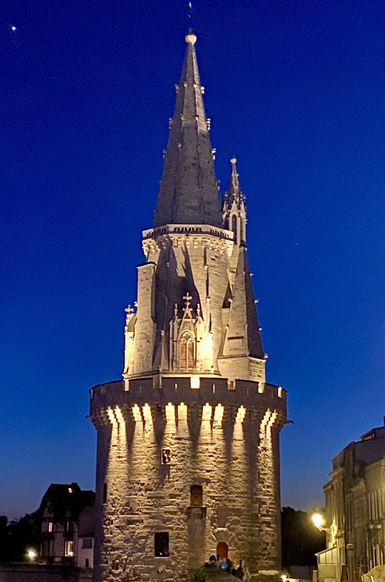
The Lantern Tower (historically a lighthouse  illuminated by bonfires), one of three towers along the only short section of city walls still in existence, in La Rochelle, at night.

The same tower in the morning during our free guided walk.  

Our guide, John, who is originally from Northern Ireland, gave us a comprehensive overview of the history of La Rochelle and took us to about 8 spots around town over 2 hours.  La Rochelle was part of the principality of Aquitaine, headed by Eleanor of Aquitaine (who married both the King of France and the King of England).  As a result the city had many privileges and rights not accorded to many other French Cities.  It was a stronghold of French Protestants who were a persecuted minority in Roman Catholic France.  In 1628, Cardinal Richelieu decided the city needed to be taken under control.  The city already had a defensive wall and control over port access, but Richelieu caused a second wall and dam across the harbor to be built and set out to besiege the city.  It took 18 months and the death or departure of 20,000 inhabitants before the city conceded.  Other points of interest:  The city now imports furniture-quality wood from American and exports grains to China.  It has a mild climate and as many sunny days as Mediterranean resorts.  During WWII, the Germans maintained a shipyard for assembling UBoats.   In addition to a thorough tour of the historic city, we were treated to a tasting of the local Cognac and aperitif wines - very tasty.  Our guide said he lives in La Rochelle because it's where he met  his French wife and has 3 children (who happen to have 3 nationalities - British, Irish and French).

The Big Clock Tower.

A 3' by 3' bronze sculpture where each column of faces represents knowledge that is passed "up" to the next generation through an open book, but if the book closes, the future generations fall apart and disintegrate.


Note the surprising cat  figure on the roof - no one knows how it came to be there.

The City Hall - the oldest city hall in Europe still in use.

The St Nicholas and Chain Towers - they are at the entrance to the inner port and historically a chain was stretched between the towers to control access to the inner harbor.  Ships had to leave behind their cannons before entering the port and pay a tax before the chain was lifted so they could leave.

The Big Clock Tower.

Jan with John, our guide.

Lunch at The Panier des Crabbes, a sailor's bar which delivered our individual orders on a single large plate of seafood (on the raised rack).  Ron, Jan and I tucking into the big prawns, brown crab, little gray shrimp, and whelk.  Our tour guide recommended the restaurant but warned us service was available only between noon and two pm

An example of the seafood plate.

After lunch, Jan, Ron, Betsy and I walked to the WWI memorial (below) since Jan's grandfather was stationed at La Rochelle.  We passed by a number of the prestigious homes including this unique one.

The World War I memorial to the local men who were lost.



Sunday, August 4, 2024

Last and final day of bike riding tour

Sunday, August 4th:  We were up early and away from Mont St. Michel on our sixth and final day of riding.  We were traveling from Mont St. Michel to the city of Saint Malo.  This is the city that was mostly destroyed by Allied bombing in 1944 and was the main setting for the novel All the Light You Cannot See.  We had a choice of a short or long ride (32 miles or 40 miles).  We naturally chose the long ride.  We left in thin overcast but dry conditions and most of our ride along the coast was dry.  But our weather luck did not hold - the last 6 miles into Saint Malo we had rain.  We were dripping wet by the time we reached the L'Univers Hotel.

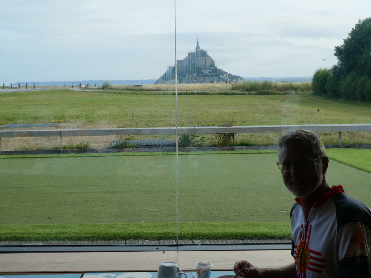
Ron at breakfast with a marvelous view.

A morning picture of Mont Saint Michel.

The gang ready to ride.

Leslie and Dennis making a turn off the busy highway onto a country road.  We had few sections on busy trafficked roads but were much relieved to ride the backroads.  The route planning by the Discover France, the bike organizer, was generally good, with slightly longer routes on less traveled roads.  But sometimes there was no option.  The one thing we can say is that French drivers know how to handle bike riders on the edge of their roads.  They always wait to pass us and always pull over to the opposite lane.  They often signal with blinkers when they move left.  I am someone who hates riding with traffic but felt pretty safe with these drivers.  Even most trucks would pull sideways, too.  It was a different story with the farm tractors which took up most of the road width.  We would stop on the verge and left them pass usually.

Sailing training (1hour for 12 euros).  This area of the route featured salt meadows, oyster farming operations, and more market gardens than we have seen elsewhere.  The vegetable crops - carrots, onions, shallots, and potatoes - are laid out in very straight rows/ridges in sandy soil.  

The seaside town of Cancale, which was the destination on the long option ride this day.  You can see how big the tides are - this basin will be filled with water at high tide.

Betsy in front, with Leslie and Dennis in background.

It started to rain a little in Cancale, and got worse as we entered the metro area of Saint Malo.  Brent and Tyrae, who rode ahead,  found our hotel and we quickly pulled our bikes inside.  We unloaded our personal gear and left the bikes/gear for good.  I must say that e-bikes are the reason we could do this ride.  We covered 250 miles in 6 days.  We averaged about 40 miles a day for 5 days, and 50 miles on the first day.  E-bikes provide great assistance on the uphills, allow for fast acceleration and sustained speed on the flats, and speedy descents due to their weight and inertia after level riding or peaking.

Saint Malo is a very large city and we rode the length of it (in the rain) to reach our hotel.  The old town sits out on a point with a large estuary to the south and inland.  The old city was destroyed in the WWII but rebuilt in a similar vein after the war.  It was traditionally a walled city. and  the ramparts were mostly spared from damage.  They are a major tourist attraction -- one can walk all the way around the walls and view the reconstructed buildings inside.  It is a 2 km walk.  Betsy and I did this walk plus went to the church in the center of town, still in the rain. 

One of several principal entry gates in the wall.

 Outside the walls.

The Grand Gate (no cars allowed through this gate, and vehicle access is limited in the old town)

A city street - note the good condition of the buildings. 

The path on top of the wall and inner face.

The beach to the south of the walls.

A new, reconstructed building.

Ditto.

A saltwater swimming pool that is flooded by the ocean, and view toward off shore forts. People (mostly kids) were swimming and splashing despite the rain.

Another fort.

The altar in the church, note the stylized animals in each corner.

A beautiful rose window in the church - modern.

Ditto.

The main church tower.

A gargoyle "spitting" water.

A typical street - the classic cobblestone pattern.

The same street showing the adjacent building.

Our hotel for the night.

The hotel was right inside the main gate and had several active pubs/bars at the entry.  Our rooms were tiny, with minimal room for drying wet gear.  We went down for drinks and socializing, meeting several Scots now living on the Isle of Jersey.  At Tyrae's urging we went for an early dinner at a Creperie - richly filled galettes for the main course and super-sweet crepes for dessert.  The rain resumed while we were eating so we hustled back to the hotel.

Tyrae and Brent were up early today to catch a train back to Paris.  We said our goodbyes, and everyone agreed that the bike ride was great.  They fly home on Monday, while we take a bus south to La Rochelle.


Saturday, August 3, 2024

Fifth Day of Riding - Granville to Mont Saint Michel

Saturday, August 3rd:  Yesterday was the fifth day of riding and a very nice one.  The roads had little traffic, the elevation changes smaller, and the weather a bit cooler.  We rode from Granville to Mont Saint Michel -- 38 miles or 60 kilometers.  I tracked closer to 65 kilometers.  We did ride out to Mont Saint Michel after arriving instead of taking the shuttle bus; it is about 1.5 miles out to the monastery.

Here are the photos:

Jan and Ron catching up to us.

The first sighting of our destination - Mont Saint Michel.

We rode along the coast for most of the day with only a couple of climbs.  This is the view down to Saint Jean le Thomas from Point de Vue.

This is the route we were following.

Mont Saint Michel over corn fields.

Mont Saint Michel from the head of the causeway.

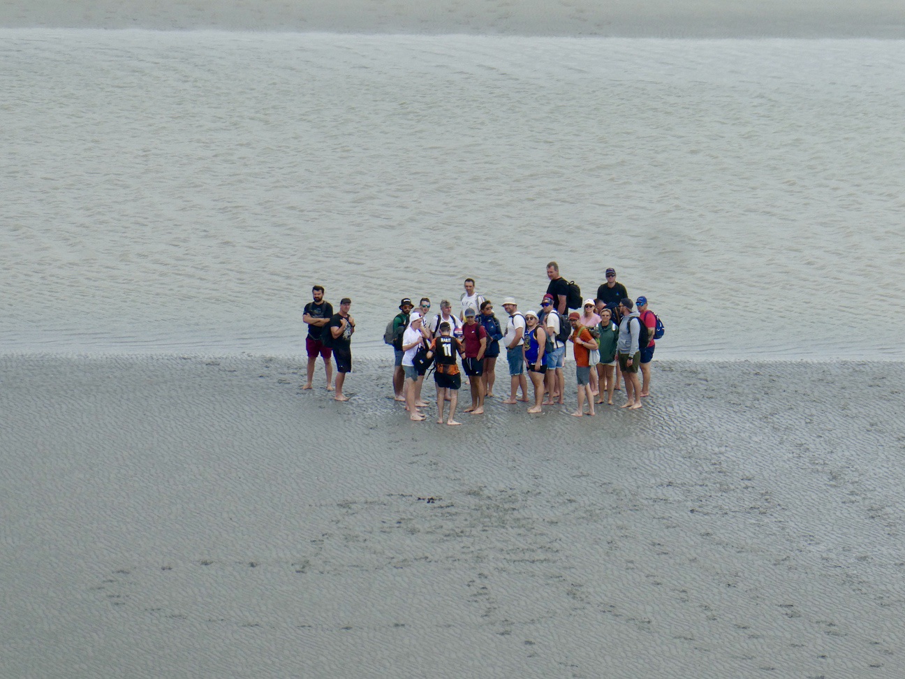
It was low tide with lots of exposed sand.  The surrounding bay was described as treacherous, with fast shifting tides and quicksand.

After parking our bikes, we entered the walled "city," fought our way directly up a narrow street (Grande Rue) with typical tourist shops and eateries on both sides, about 100 feet in height and 0.1 mile long.  But with the hordes it took some time.

After reaching the ticket line, we continued up steps, purchased entry tickets and rented an 45-minute audio program, and then climbed the last 90 steps to the church entrance.  We toured around the monastery (about 12 major rooms) by going up and down steps, through stone hallways, and twisting in numerous directions.  The monastery is massive, built on top of the granite island, in the shape of a Roman Cross.  There are "pillar rooms" under the church floor supporting the 4 ends of the cross that is the floor plan.  They are a forest of large stone columns and were probably crypts originally.  

According to the audio history, the first church on this location went back to the 7th century, then a small gothic building was added.  The Duke of Normandy funded the final, grand development of the site in the 12th century.  It seems there were only 30 to 50 monks resident in the abbey, but pilgrims came in vast numbers and there were many important visitors as well.  We saw a huge banquet hall and there must have been many sleeping chambers hidden behind the walls.  Another large, well-lit room served as the Scriptorium, where the monks created and copied manuscripts that would have provided revenue.

A telephoto shot of people who are walking over the sand, like true pilgrims.  They appear hesitant to cross the water in front of them and are looking back toward the monastery.

The central tower.

A view looking back to the mainland and the causeway.

The highest terrace and outside face of the largest church.

The Cloister, which is on the highest level, next to the church.

The Cloister columns.

A barrel roof in the guest hall.

A walking wheel for hoisting supplies up.  The Mont became a prison during the French Revolution and prisoners would walk on the inner rim to power the wheel's rotation.

An aerial shot (photo of a postcard).

The cloister is behind the 3 windows on the upper level.

Back down on the main street.

The view from our hotel room at Le Relais Mont Saint Michel.  Mont Saint Michel is peeking up on the left side of the trees.

Dinner at la Ferme Saint Michel.

Additional observations on the bike ride.  The country we traversed changed somewhat as we moved westward.  The entire area is covered with corn and hay fields, with haying operations in full swing - we frequently had to dodge big, scary, haying rigs.   The area near the D-Day beaches had lots of cows, mostly spotted white and black, but some Charolais (tan).  As we came toward St. Lo, there were many horses and equestrian facilities (there was even a horse show happening in St. Lo).  When we were on the coast, the terrain was reasonably level but inland it was undulating.  The coastal land near Mont St. Michel was mostly salt marshes where sheep and a few goats graze. We saw very little forest land.  Wildlife sightings consisted of sea gulls, crows, and big wood pigeons, although Betsy spotted 2 ferrets (or weasels) near Utah Beach.   

Most residential buildings are constructed of stone, with wooden shutters, and abundant, well-tended flower boxes.  After we left Granville we passed through a resort area with many cute holiday homes and pine trees.  The villages tend to consist of rows of connected stone buildings, as do most of the farm operations. The stone masonry is universally impressive, and the amount of rocks removed from fields or quarried and then brought to building sites is mind boggling to imagine.  We would guess that the stones have been used many times to build structures over the 2,000 or more years this area has been inhabited.