Thursday, August 3, 2023

Upper Midwest Tour, Days 24 and 25 - Aug 2 & 3

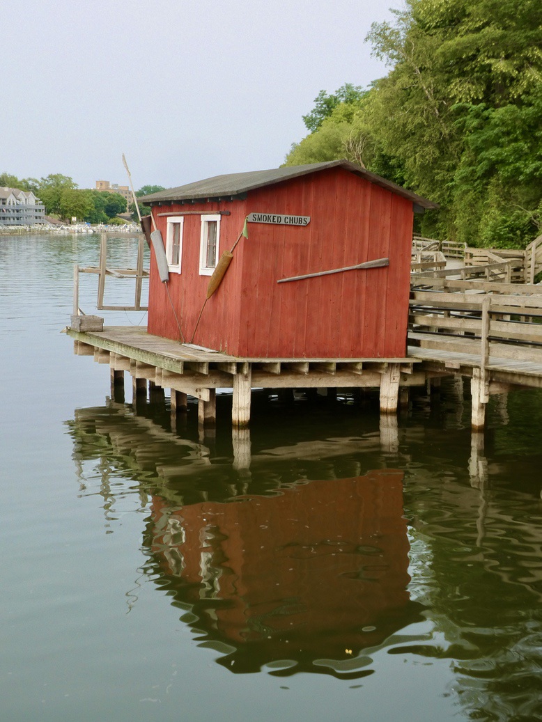
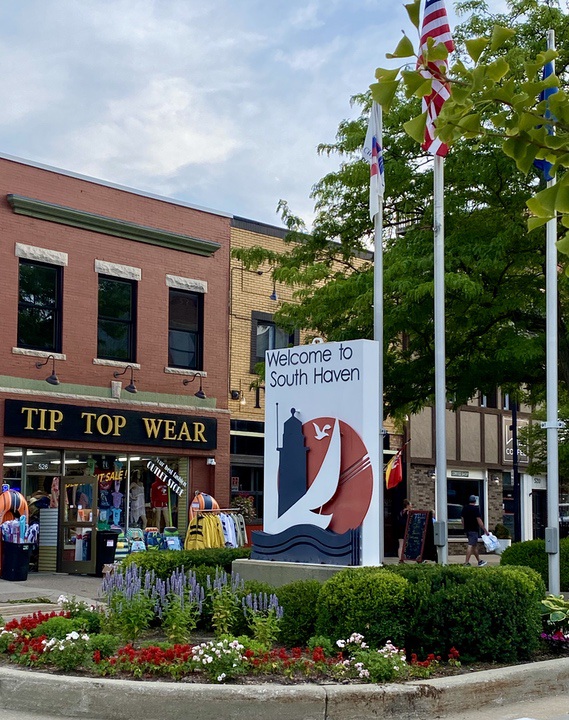
Yesterday was a tough day for us -- thirty five miles on the bikes.  After breakfast at the Van Buren State Park campground, we took off on our bikes.  We first rode north from the Park to South Haven on the Van Buren Trail, a very nice smoothly paved, level path to town.  It was about 6 miles to town, then another 2 through the town on residential streets and by the marina to the trailhead of the Kal-Haven Trail.  This is a 32-mile rails-to-trails route running from Kalamazoo to South Haven.  It is one of the first trails in Indiana and one of the longest.  Its surface is labeled as limestone chips, but the 10 miles we rode was more packed dirt, with occasional chips and sand.  It was smooth and easy to pedal.  We rode from South Haven to Grand Junction, about one third of the way to Kalamazoo.

Things went well, but I suffered a couple of mishaps.  First, we stopped to read about the seven bridges on the trail and as I went back to photo the covered bridge over the Black River, my bike fell over into a patch of poison ivy.  I gingerly picked it up and worried about itching the rest of the trip (so far no problem).  Secondly, as I was riding along, a grasshopper jumped on my face, hitting just below my eye and lodging inside my sunglasses.  I reacted quickly to brush it off and may have hit myself in the eye trying to get it off.  The lower lid of my eye stung the rest of the ride.   Today, I awoke with the injured site swollen and tender to the touch.  What an unusual injury.  Thirdly, at the turn around point, I swung wide off the trail to complete the turn and went over a patch of prickly pear cacti.  I immediately checked for thorns, but fortunately, found none and have not had any flat tires.  The ride back to the camp was uneventful.  Even with the mishaps, the ride was quite satisfying.


One of seven bridges, the only one that is covered.


After the ride, we changed into swimming gear, rode over to the beach on Lake Michigan, and went for a swim.  It was cool but felt great - like a decent seaside beach, with clean soft sand and no salt.  For dinner, we went into South Haven to the South Haven Brewpub.

The draft beer list - all made in house, some with unusual names.

After dinner we strolled the Main Street, about 3 blocks of small shops, etc.

With very nice manhole covers.

Today, we struck camp and drove to Indianapolis, IN, a relatively short distance (about 3 hours).  We checked into the Fort Harrison State Park Inn a few miles northeast of the city.  It is a historic-looking inn with officer-type housing scattered around the grounds.  We are looking forward to showers, a soft bed and not having to crawl around on the ground.

Our only real sightseeing today was to drive into downtown Indianapolis and complete a "volkswalk" around the capital and surrounding area.  The start box for the volkswalk was in a visitor center at a state park that borders this area.  We started out and completed most of the walk in 88 degree temperature.  It was a bit hot so we did not go very fast.

Indianapolis has a well developed downtown with numerous parks, a canal with paths on both sides, many museums, many public sculptures, and possibly too many grandiose military monuments.  I photographed a sampling of these.  We also went by the NCAA Headquarters and ended up at the State Capital, with its pair of large government offices behind it.  The Capital looks clean and well groomed.


The canal, with gondolas and swan paddle boats


The largest Scottish Rite Temple we have ever seen.


WWII Memorial.

Civil War Memorial.

The State Capital building.


We drove slowly out of downtown, getting back to the Inn via city streets rather than the highway.  We found a Mexican restaurant on the edge of the State park property and decided to ride our bikes to it.  Dinner was great and generous.  We rode back passing around the row of officer homes - red brick with white porches and trim, very nice, reminds us of Ft. Vancouver or Ft. Worden (at Port Townsend), only larger.

On to Illinois tomorrow.

Tuesday, August 1, 2023

Upper Midwest Tour, Day 23 - Aug 1st

After packing up our camp and finishing yesterday's blog,  we left Orchard Beach CG at about 11 am, and drove south to the Van Buren State Park, again on the east side of Lake Michigan.  We stopped in Muskegon for a break at the Coffee Factory, rated a 5.0 by Google maps.  We drove a slow road  (infected with stop lights) the rest of the way to the park, which is just south of South Haven.  We set up our campsite.  The park has over 200 sites and most are occupied with the usual monster trailers.  However,  there are a greater number of tents, a lot more trees, and our site feels more private than the one at Orchard Beach.

After the setup, we took a short bike ride through the campground and then found a spur to the Van Buren Trail which goes north to South Haven.  The official trail also goes south to Hartford.  It is paved and should be a great access to the Kal-Haven Trail that is a rails-to-trail route going over 30 miles to Kalamazoo, roughly east.  More on that tomorrow, I hope.

We took a side road on the way "home" and had a couple of notable sightings -- a black squirrel, a woodchuck (or groundhog, a kind of marmot), and a friendly calico cat with no tail.  Earlier while in South Haven getting dinner supplies and visiting the post office, we had another unusual sighting - an MRAP (Mine-Resistant Ambush Protected) vehicle.  You may wonder why this is noteworthy - well, we just listened to an audiobook written by Craig Johnson, whose main character is Walt Longmire, the sheriff of Absaroka County, Wyoming (fictional county).  In the story, the neighboring sheriff department was gifted one of these monster vehicles and Sheriff Walt got to drive it - he was the only person who knew how to start it and used it to subdue the bad guys in the story.  The real MRAP we saw was owned by the South Haven Sheriff's Department.


Woodchuck, eating acorns.


A black squirrel, also eating acorns.

We also rode to the beach access point in the park, looks inviting.  Lots of people were on the nice sandy beach and a few were in the water. It feels like we are on the New England shore, without the salt water.

We enjoyed a nice dinner of bison burgers and cucumbers, watching campers go by on bicycle or on foot with cute dogs,  


Upper Midwest Tour, Day 22 - July 31st

Today was Sleeping Bear Dunes National Lakeshore, one of three national lakeshores in the US.


Our first stop, after getting up and having a campground breakfast (I made Apple Crisp along with sausage, cheese roll), was about an hour north to Sleeping Bear Dunes Visitor Center.  We did a quick spin around the center, getting an overview of the natural history of the lakeshore (plants, animals, and geology), and a strategy for touring the park.  We all know how the Great Lakes were formed (by large, mile thick ice sheets), but what may not have known is that as the ice sheets retreated, the weigh depressed the crust of the newly formed lakes and water flowed north.  Then as the ice melted further, the crust rebounded and the water flow reversed to what it is today , south and east -- water and ice are heavy.... 

From the Visitors Center:  An example of a Petoskey Stone - hard to see but every little circle was an organism that was fossilized.

A more typical bivalve shell fossil.

Our tour strategy was to drive to the scenic, one -way loop that sampled the park's highlights -- the Pierce Stocking Scenic Drive (Stocking was a lumberman who developed the road to share the beauty with friends and travelers), with 12 signed stops.  The first site was a covered bridge - we all know why they were constructed -- it is easier to replace the roof rather than the structure supporting the road, after weather decay.

Next stop on the drive was a first look at the dune country and the Cottonwood Trail.  We walked the trail, getting intimate with the sand.  The dunes are largely thousands of years of built up wind blown sand from ancient moraines.  Grasses and low plants first stabilize the sand, which allows shrubs and trees to take root and build a layer of topsoil.  The "climax" of this progression is a hardwood forest of Beech and Maple trees, which can be very beautiful.

On the trail.

The Dune Climb -- note the parking lot on the right side of the photo and the people walking up.

Little Glen Lake, an example of how the original Lake Michigan edge is reshaped smoothly  land that juts out is eroded to fill in the inlets, often leaving isolated lakes behind).  This whole area is covered with lovely lakes.  We learned that most lakes have a brownish tinge as water flows in from streams laden with tannins. "Crystal" lakes are filled from groundwater sources, so no tannins.

The penultimate spot on the drive was the Lake Michigan overlook -- note the platform and the many other tourists.

There is an impressive slope of steep sand which attracts people to run down 400 feet or so.  Of course, they need to climb back up, which is not easy.  By using a level app on my phone, I estimated the slope angle at 36 degrees.

The top bluff.

View looking south to Empire Bluffs.  You can see how steeply the dunes rise from the lake.

After the drive, we went slightly farther north to Glen Arbor, a resort area with kayak/float trips on the Crystal River.  We were looking for the Port Oneida Historical Area, found nothing other than a nice summer camp and a few farmsteads.  Crystal River is a short, meandering creek flowing from Glen Lake across a 2-mile land barrier to Lake Michigan.

We drove south to Manistee, directly into town for dinner at TJ's Pub (Stormcloud IPA, Shandy, Duck wontons, and salads).  The Manistee River splits the town in two and, after dinner, we strolled along a pleasant board walk to the park and jetty where the river flows into  Lake Michigan.  We passed a a few marinas with sail boats and fishing cruisers, some attractive townhouses, and saw two small deer herds.  A curious thing, how we see more "wildlife" in urbanized areas than we do in the outback . . .

TJ's Pub.

Along the River Walk -- both sides lined with docks and various types of boats.


The Lighthouse at the entrance of the river at Lake Michigan.

We returned to the campground in time for bed.  Tent camping is fraught with difficulties, since most folks come with monster RVs that have annoying lights that burn all night and machinery that runs all night.  Campers also tend to keep fires burning in the fire pits too much of the time.  It's hard to see stars or hear birds with that kind of annoyance in the background.  But the Michigan  State Parks have good facilities, with flush toilets, showers, lots of hot water, electricity and conscientious staff. 
Onward we go.....