Thursday, January 19, 2023

New Zealand Day 6

Today was spent walking around Christchurch seeing the sights (and covering 7 miles).  The photos will give you an idea of what we saw.  We started after breakfast from our hotel (Chateau On the Park), passing through the Botanic Garden, the Arts Centre (where we stopped for refreshments), along the River Avon, through various parts of the city (following a tourist walking route), the Library (where we went up to the 4th floor to look down upon the Cathedral (being rebuilt) and finally some more of the city on the walking route.  Our group split up and went back to the hotel using different routes.

After getting back to the hotel, Betsy and I enjoyed a brief sit by the hotel pool along with a brief dip.  We meet up at the bar for rehydration, and made reservations for dinner at Dux Dine.  The restaurant was about 4 blocks from the hotel in what looked like someone's home.  The dining was quite pleasant (fish for Varis, spanakopita for 3, and halloumi salad for me).  We enjoyed lemon tarts with ice cream for dessert.


A great dahlia garden


The Rose Garden


The Arts Centre

The Arts Centre Memorial Window with famous people (the who's who is below)


Free floating art

Glass feather

Feather is about 5-6 feet tall

The Observatory (now a hotel)

Statue of Robert Scott, South Pole Explorer, who died on his return

Various things in Victoria Park


Queen Victoria


A site of a collapsed building, not yet rebuilt; there is water emitting from the car as more art.


View of Cathedral -- construction will be going on for some time

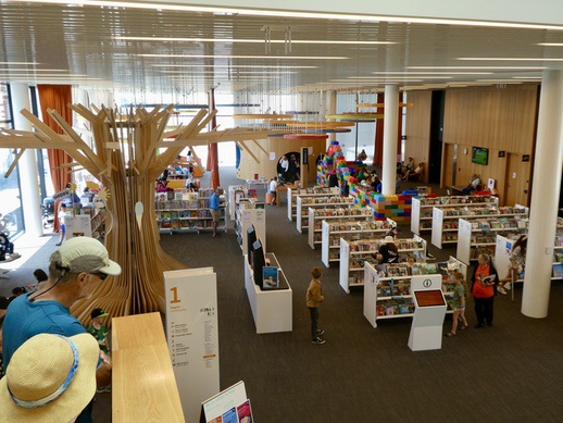
The kids floor of the library - tree and giant lego blocks

A great faux building front. . . .

The entire wall is flat.


Wednesday, January 18, 2023

New Zealand Day 5

After spending the morning exploring central Greymouth, having "elevenies" at a local coffee shop, and buying a few snacks for the afternoon, we caught the Trans Alpine Express for a reverse trip from yesterday, back to Christchurch.  

The first set of photos were taken while strolling around Greymouth:


Art work advertising Shantytown, a family tourist destination

Our hotel
Note the name - was a bank, now something "new"

Signal Station

View from our hotel room; fortunately, the pile driver didn't start until after 8 am.


What drove early Greymouth

Public Art - the hair is alive.


The founding of Greymouth

All five of us (Jan, Ron, Varis, Betsy and me) were at the train station, with our luggage a little before 1:00 pm after getting snacks.  The train arrived only a few minutes late, disgorged the day's arriving passengers, pulled down a little further to a switching yard to move the engines from one end to the other and moved back to the platform.  We boarded and settled in for the five hour trip back over the Southern Alps back to Christchurch.  I took a few photos and added some more bulleted notes from the pre-recorded commentary.  Betsy, Ron and I spent some time in the open air observation car when we were traveling through the "Broken River" section.  We arrived in Christchurch by 6:30 pm; taxied to our hotel and had dinner in the hotel restaurant.

Here are my additional bulleted notes:

·       Four WWII German U-boat engines were used to generate electricity in Dobson (named for the brother of Arthur Dobson (Arthur’s Pass), and the local folks could feel the vibrations.

·     The Grey River is a major river running from Christabel Lake at the divide to the Tasman Sea.

·     Coal mine disaster occurred near Stillwater next to river (Brunner) where 65 men died; all disasters caused by methane explosions.  Miners from socialist party and went on strike for a 30-minute lunch period (over a 15-minute break), ultimately pushing for an 8-hour work day.

·     Greymouth is known historically for gold, coal, and timber.

·     Gold rush on the West Coast began 1864; 29,000 miners came, some were the CA 49’ers.

·     Arnold River is a short river from Lake Brunner to the Grey River, known for fly fishing.  Jet boats are banned on the river.

·     Thomas Brunner, a surveyor,  was the first European to view the lake named after him.

·     Alpine Fault earthquakes average period is 330 years, ranging between 140 to 500 years.  The last major earthquake was 1710.

·     Sawmills were frequent in number between Moana and Inchbonnie, springing up to feed the gold rush towns.  The forests are known as “the Bush.”

·     Red pine is a favored lumber before WWII.  Logging is mostly over and restricted.  Present day logging is on introduced species.

·     The Otira Tunnel was the 7th longest tunnel in the world when it opened.  But it is now 45th longest.  There are two longer tunnels in NZ.  Most of the longest are under the European Alps.

·     Arthur's Pass (where the highway crosses) is at 3,000 feet, but the rail tunnel travels under it and emerges at Arthur Pass Station.  The station is at 2,418 feet, the highest point for the rail line.  The tunnel rises 820 feet.

And finally some more photos:

The Trans Alpine Express arriving

Lake Brunner, largest lake in this region


The "Broken River" section


Tuesday, January 17, 2023

New Zealand Day 4

Today, we arose early and traveled by the Trans Alpine Express train to Greymouth on the west coast of NZ.  We were at the train station in Christchurch (on the east coast) by 7:45 am, in time to board by 8:00 am.  The train traveled over the Canterbury Plain the first third of the total trip, then climbed through the foothills up to Arthur's Pass for the second third of the trip and then cruised down to Greymouth on the western side of what is known as the NZ Alps.  The day started out gray and cloudy so we didn't expect good viewing.  But the weather improved as we headed west and turned out to be very nice.

The train provided what turned out to be excellent recorded commentary that we listened to with headsets.  This commentary was quite informative and ranged over a variety of topics.  After a few "episodes" I decided to summarize it as somewhat random bullet points that I have copied into this post.

Train ride on Trans Alpine Express:

·    Train departed at 8:10 am; arrived in Greymouth at 1:30 pm.  This train service started in 1987, after other routes and services were abandoned, and the highway was fully “sealed” (i.e., paved).

·    Canterbury Plain rises from sea level to 1,300 feet before reaching the foothills/mountains.

·    The plain produces 60 to 80% the agricultural products for NZ.

·    Dairy is most important product on the plain and in the high country.  Hereford cattle are brown and white; Angus are mostly all black. 

·    Hedgerows are dense, tall and frequent for wind breaks.

·    Northwesterly winds characterize the area.  They can be dry, sucking moisture.  Rains come the southerlies off the eastern ocean.

·    Waimakariri River started as a glacier that carved the river bed.   It  is considered a braided river – a braided river has steep slopes and has a high sediment load, creating gravel islands at flat spots.  It is a geological river form found in Alaska, Western Canada, and this area of NZ.

·    Gorse and Scotch Broom were introduced for hedgerows by English settlers. but are now noxious weeds without natural enemies.  The seeds can last 40 years underground and can shoot 40 feet from the plant.  The plants can be killed by native species that grow up and form a canopy over the bushes.

·    Railway viaducts are steel or timber trestles structures here that are quite high as opposed to European style, flatter, arched, long bridges.

·    Beech forests once thrived but were reduced in number with climate change.

·    Pacific plate collided (subducted) with Indian Australian plate to create the Alps.

·    Broken River Stagecoach region – slow and many turns, narrow ledges falling down to the river. 

·    High country sheep stations – 99-year leases, poor quality soil, fences not needed, many acres to support a single animal, border collie dogs (two specialties "herders" and "run away)", merino wool from the sheep (Merinos).  Declining breed because the market for this wool is down.

·    The middle zone of  high hills, mostly grass covered, have many stream cuts that allows rock scree to “flow” down, creating wide scree fields when they meet the flat ground; early“ developers” attempted to burn off the tussock – “firing off.”  The land receives relatively little water since it lies in the rain shadow of the higher western peaks.

·    10,000 years ago the last glacier ended;  it stretched from Springfield to the coast 18,000 years ago.

·    Polar Range is the highest and is in Arthur’s Pass National Park

·    Town of Cass famous for a “Red house,”   painting that hangs in the Christchurch Art Museum - the piece was considered the first "authentic" New Zealand art.

·    There is an Ironman Coast to Coast race, which has running, biking and kayaking sections.  Record times are 10 and 12.5 hours for men and women, respectively.

·    Three million tons of gravel are transported to sea each year by the Waimakariri River.

·    Luxury accommodations available at Arthur’s Pass – Bealey Village and there are other posh lodges in the area.

·    Kea birds are believed to be very intelligent and curious of humans – olive green with orange under wing.  They, along with Kiwis, are found in the Park.

·    Arthur Dobson was a surveyor, who with his brother explored 5 passes.  He died in 1934.  Altitude at Arthur’s Pass train station is 2,700 feet; the pass is 3,000 feet.

·    Trees on east side are not good for anything but firewood; trees on west side are very different – they get warmer temperatures and more rain. 

·    The transmission towers and poles have double I-beam supports from 5 to 10 feet above ground.

·    Otira Tunnel descends  from the pass just after the Arthur’s Pass Station – it is 8.5 km long and was opened in 1923, then the longest in the Southern Hemisphere.

·    After the tunnel, we followed a tributary of the Taramakau River, picking up the main river at Jacksons.  The river was the main Māori route from the west to east.  The terrane was a wide flat valley where mountain sediment has filled in glacial cuts.

·    The Alpine Fault comes in from the southwest and then goes northeast at Inchbonnie, a significant boundary between the two tectonic plates.  The fault is visible from space and causes the uplift of the NZ Alps.  Uplift is rapid in geological terms at 5 to 7 millimeters per year.  Most of the earthquakes occur along this fault line that runs up through Marlborough County and then on to the eastern portion of the North Island.  The Indian-Australian plate to the west is very old  and was subjected to extreme pressure, moves slowly and has the oldest rocks in NZ.

·    Greenstone (jade) is found on the west coast and treasured for carving tikis, etc.

·    We passed Lake Brunner, a large lake with a vacation village of second homes and marinas – Moana.

·    Podocarps form 90% of the native trees in NZ and are evergreen.  They have fleshy cones.  Deciduous trees were all introduced -- beeches or birches.

·    Mining continues in this area, following late 1860-90 gold rushes.  Coal is the principal current product.


Here are a few photos to go along with some of the bullet points above:


Viaduct

Coming into the foothills and first view of the Alps


Scree tracks down the high hills

A very large "slump"

At the Train Station, just before the Otira Tunnel

After arriving in Greymouth (surprisingly warm and sunny) about 1:30, we checked into our hotel and went for a walk across the Grey River and out to the end of the jetty on the north shore.  The hotel receptionist said that dolphins might be visible out there (no luck).  We walked mostly on a path atop a levee, but just before the jetty, we bypassed a race track that waslsetting up for afternoon races.  After the jetty, we returned the way we came except for a diversion around Copban Lagoon inside a natural area (full of blacks swans and grey ducks).  We missed the racetrack action, though we could hear it almost all the way back to the bridge.  

Contact was made with Jan and Ron, who had arrived mid-afternoon, after driving north from Franz Joseph, along with Varis.  Jan and Ron came out to meet us at the bridge as we were returning to town.  Varis was resting up in his room.  The four of us traversed back over the bridge, and stopped in at Speight's Alehouse for a drink.  Varis was called and he walked down the 4 blocks or so from our hotel to join us.  After one round, we decided to eat dinner here and moved to the dining room.  After the hearty fare, we walked back to our hotel (Copthorne) to await sunset, which is supposed to be spectacular.  More on that tomorrow.


Monday, January 16, 2023

New Zealand Day 2 & 3

We made it, leaving both Portland and San Francisco in pouring rain and arriving in Auckland after a 13.5 hour flight.  We then flew on to sunny Christchurch, on an earlier flight than what we originally booked.  The flight to Auckland was on a Boeing 787 and the 27 people in Business Class had fold-down seats that converted into comfortable beds.  The flight attendants had to change each seat into a bed with separate mattress pads -- the first time we have seen this set up.  It is something that the attendants say they have been doing for 20 years.  They expect to get new planes in a year or two with a more standard arrangement.  The Air New Zealand Business class service was very nice  - I ate well, drank much, watched two movies (Mission Impossible Fallout, and Minions and the Making of Dru), and slept for about 5 hours or so.  Betsy also slept well.

We passed New Zealand passport control and biohazard inspection easily, reclaimed our luggage, walked about a mile from the international terminal to the domestic terminal, checked in for the short flight to Christchurch, rechecked our luggage, had some snacks in the lounge, and finally took off.  We had pre-booked a transfer from the airport to our hotel, which worked fine after we found out where to meet the driver.  It turns out the driver drove for Uber and was contracted by the middle people to drive us.  Had we known, we could have just used Uber and saved a few dollars.  Anyway, we were early for check-in at the Chateau on the Park, DoubleTree by Hilton Hotel.  So we stored our luggage and went for a walk around Christchurch.

Our route went along Hagley North and then Hagley South Parks.  After seeing the train station (where we go tomorrow for our day trip over the Alps), we walked to the city center along more of the park.

Reaching the River Avon, we saw punting for the tourists.

We followed the river along the Avon River Pedestrian Way, passing a memorial to the 185 people who died or were seriously injured in the 2011 earthquake (names are scribed on the wall).

This is the Friendship Memorial Bridge, a monument to WWI, with a busker performing in front.  Turns out there is a busker festival occurring now in Christchurch.

A dragon in the river.

The Christchurch Cathedral was heavily damaged in the 2011 earthquake and is still undergoing significant renovations - a new 'raft' (floating) foundation, internal bracing and then rebuilding.

A "steampunk" painting/mural on two sides of a building, art that I to see.

On the way back to the hotel, we went through the park, passing into the Botanical Garden.  This is a patch of varied colored dahlias.

And, a rose garden, with all colors represented - this is one of my favorites.

And, a tree fern, a NZ speciality.

And finally, a kauri tree, one of the most useful NZ tree for lumber.

After 5.3 miles, we arrived back to the hotel.